|
|
||||||
| |
|||||||
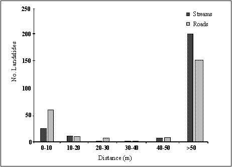
| Landslides on logging roads are an ongoing problem for water quality in the Otways |
|
Initial SKM Research Supports the Argument there is a Link between Landslides and Roads in the Otways
Two significant limitations in the above analysis must be recognised. First, the mapped landslide information used only represents at most 50% of the landslides estimated to exist. The majority of these slides are based on work by Cooney (1980) whom interpreted aerial photographs (1:16,000 scale) of the whole region. The photographs were taken between 1946 and 1950. Conney (1980) stresses the difficulty in identifying landslides in forested areas using this method. Hence, the spatial distribution of the landslides shown in Figure 4.1 (not shown) is heavily biased to areas where tree cover had been removed. Secondly, the dates of when each of the landslides occurred have not been assigned. Hence, it is possible that this analysis could have related the occurrence of a landslide with a road, despite the landslide having occurred first. It is important to understand that the above analysis does, therefore, not attempt to establish causal links, but rather provides preliminary evidence as to whether they may exist, in which case more detailed investigations may be warranted. Nonetheless, the findings are supported by the available literature for the Otways. Source: SKM. Page 118, 119. |