West RFA natural landscapes identification and Assessment
The West RFA National Estate Identification and Assessment in the West Region of Victoria assessed Natural Landscapes as large, relatively undisturbed areas with topographic and catchment integrity where natural processes continue largely unmodified by human intervention.
See the report, West RFA National Estate Identification and Assessment
in the West Region of Victoria, at the Commonwealth Government RFA
website:
http://www.rfa.gov.au/rfa/vic/west/raa/natest/index.html
|
The evaluation however put a limit to the size of areas requiring them to be greater than 3000 ha. Who decided this limit? Given the Otways is fragmented by agriculture and plantations, this threshold has excluded many smaller but significant areas(catchments) in the 1000-3000 ha range with high natural landscape values. Hence the identification and assessment of natural landscapes values as part of the West Regional Forest Agreement was inadequate.
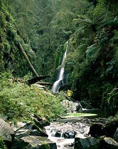
Wye River falls and gorge was excluded from natural landscape assessment due to the catchment being less than 3000 ha |
 |
In the Otways only three areas were identify as having high natural landscape values and are show on map - sheet 5.
These are:
- Cumberland River area. 3,139 ha
- Carlisle State Park /Link Track area 5,058 ha
- West Barham river/ Clearwater Creek area. 6,599 ha
See the pdf version of map 5 of the report, West RFA National Estate
Identification and Assessment in the West Region of Victoria, at the
Commonwealth Government RFA website:
http://www.rfa.gov.au/rfa/vic/west/raa/natest/index.html
Don't know the meaning of a word? Check the glossary.