Land Conservation Council
Scenic Assessment of Streams
The first official (government) acknowledgment of the scenic values of the Otways were acknowledged by the Land Conservation Council (LCC) 1978 - Final Recommendations Corangamite Area.
|
However more comprehensive research was done a decade later as a part of the LCC 1989 Rivers and Streams Special Investigation that ultimately resulted in some Victorian rivers obtaining Heritage river status. Link Heritage Rivers In 1988 consultants put together a report titled A scenic assessment of Victoria's Rivers as a part of the LCC review.
|
 |
The study put rivers into different categories based on the environment the river flows though. These categorises were:
- Natural
- Semi-Natural
- Farm-Forest
- Agricultural
- Small Town- Suburban
- Urban-Industrial
Click here for a more detailed description of each category.
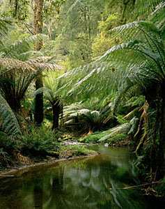
The study found 21 rivers in Victoria with high natural scenic values. Four of these were in the Otways and include:
- Gellibrand. (Semi-Natural)
- Aire. (Semi - Natural)
- Cumberland. (Natural)
- Erskine (Semi - Natural)
See extract from A scenic assessment of Victoria's
Rivers. Link
The Cumberland river was the only large river in Central and Western Victoria found to exist in a essentially natural environment. Link
The results of this study indicate that Victoria's scenic rivers occur mainly in the East of the State and the Otway Ranges. In Western and Central Victoria, land clearing for agriculture and subsequent erosion have had a significant impact on the scenic quality of rivers.
Research Limitations
The reliance on aerial photography along with limited time, have been acknowledged as limiting factors in doing a proper assessment in A scenic assessment of Victoria's Rivers. Link
The 1989 LCC Rivers and Streams Special Investigation (page 59) also acknowledged the limitations of using aerial photographs and suggested better information can be obtained with field inspections and local knowledge obtained though public submissions.
Due to the large numbers of rivers that needed to be assessed, smaller rivers and creeks were not done. For the Otways, smaller rivers such as the Wye, Kennett, Grey, Carisbrook, Smythe and St Georges have never been assessed for aesthetic values.
References
1978, LCC - Final Recommendations Corangamite Area.
1988, Aug - A scenic assessment of Victoria's Rivers prepared for the Land Conservation Council special investigation of Victoria's Rivers and Streams
1989, Sept - LCC Rivers and Streams Special Investigation.
Extract: A scenic assessment
of Victoria's Rivers; 1988. (Page 33)
3.3 ISSUES
It must be noted that the results from this procedure
are only preliminary. A number of issues arising out of the assessment
procedure and the evaluation process when applied to Rivers on a broad
scale.
33.1 ISSUES IN THE ASSESSMENT PROCEDURE
Number of Sites :Assessed
Due to time constraints and the magnitude of the sample, not all Reaches mapped in the classification phase have been subjected to the assessment process. For purely pragmatic reasons it was necessary to reduce the sample size. However, all major rivers and creeks have been subjected to the full assessment process, while smaller creeks flowing through potentially less scenic areas, (identified during the classification phase), have not.
Number of Criteria :Assessed
The actual number of positive and negative features assessed has varied for each Reach. This is due to a number of factors:
1 The scale of available aerial photography. Coverage varies across the State.
2 Some criteria are not readily assessable using aerial photographs. This is particularly apparent in the Cultural/ Wildlife categories. (c.f. below).
3 The extent of overhanging canopy excluding waterform from view.
4 The extent to which a river has been field checked.
Reaches have the potential to score more highly in positive and negative features, where it was possible to assess a greater number of criteria for one or more of the above reasons. This creates a bias in favour of Reaches which were assessed in more detail. To indicate where a bias has occurred in this manner number of actual criteria assessed for each Reach, and the total number of possible criteria in each River/Landscape Setting is indicated on each Summary Table (Appendix C).
Type of Criteria Assessed
In some cases, it was impossible to assess certain criteria from aerial photographs. Specifically, Cultural and Wildlife criteria are almost impossible to assess using Aerial Photo alone. Therefore in Small Town, Agricultural and Farm Forest Settings the lack of information about Cultural and Wildlife criteria may weight the assessment results. In Small Town Settings for example, where Cultural features are an important component in the assessment process, this bias may be significant.
RIVER-SETTING CATEGORIES
Extract from LCC Rivers and Streams Special Investigation 1989. (Page
153)
Natural
Cultural changes are not visually apparent. The
river has not been modified and the river can usually only be reached
on foot.
Semi-natural
Cultural changes may be visually apparent
but do not dominate. These changes may include isolated structures such
as dam walls and diversions. Road and rail access may exist, but is not
along the river banks.
Farm--forest
Visually dominant changes are scattered through
more natural areas, such as occurs where natural vegetation is mixed with
areas used for agriculture. River works may occur and small farm dams
are common. Vehicle tracks to and along the river are common, but are
screened by surrounding vegetation.
Agricultural
Major clearing for agricultural uses has
occurred. Patches of natural vegetation may remain but are usually restricted
to stream,-sides and along fences or roads. Changes to the river may be
common. Small and large dams are very common as are farm buildings and
structures. Vehicle access to and along the river is likely to be well
established and clearly visible.
Small town--suburban
Suburban housing dominates visually. Rivers
may be substantially modified by flooding mitigation works. Rivers may
flow through parks or developed areas. Vehicle access to and along the
river is likely to be well established.
Gellibrand River.
Extract from A scenic assessment of Victoria's Rivers 1988 (Page 20)
Gellibrand River
There are two Reaches on the Gellibrand River. Both
are highly scenic. They are Southern Uplands/Farm Forest (1) and SU/Agricultural
Setting (2). The Farm Forest Reach (1) flows through the Otways and has
highly diverse stream flow patterns, many oxbows, diverse vegetation and
isolated terraces. Within this Reach both vegetation clearings and a small
quarry detract from the scenic quality. The Agricultural Reach (2) which
flows to the sea, is highly scenic due to the presence of dunes, sandbars,
terraces, diverse coastal vegetation in remnant stands, and swamp vegetation
in the Viewshed. The river has extended sections of deep calm clear water
before it flows into this wetland and then to the sea.
Cumberland, Erskine and Aire Rivers
These rivers flow from the Otway Ranges to the sea.
The first Reach in each River makes up almost their entire length, and
each displays high scenic quality. They are Cumberland River, Southern
Uplands/ Natural Setting (1), Erskine River, SU/Semi-Natural Setting (1),
and the Aire River SU/Semi-Natural Setting (1). The high scenic quality
rating for these Reaches is due to a combination of distinctive peaks,
sharp crested narrow extended ridgelines or steep escarpments, diverse
natural vegetation in the Viewshed, and highly diverse stream flow patterns.
The scenic quality of the Cumberland River is further enhanced by the presence of rockfaces, cliffs and the spectacular Cumberland Falls.
Large boulders and rock outcrops, a highly meandering stream section, and the Aire Falls add to the scenic quality of the first Reach of the Aire River. The Coastline/Agricultural Reach of the Aire River (3) flows to the sea where dune formations, sandbars and diverse remnant coastal vegetation are present. This Reach is also highly scenic.
The Erskine River has two significant sets of falls.
These are the Erskine and Straw Falls. It also has numerous cascades and
isolated hanging valleys. Fords cross the river and a natural amphitheatre
named 'The Sanctuary' occurs in the Viewshed. Small clearings in the natural
vegetation detract slightly from the quality of this Reach.
Don't know the meaning of a word? Check the glossary.