|
River Anger
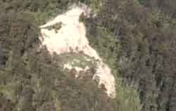
"A MASSIVE landslide deep in the Otway Ranges has been described
as an ecological disaster by conservationists"
The land slide which has severely damaged the East Barham River with
siltation, was reported in the local press after 90 local and concerned
environmentalists blocked the road to a nearby logging coupe.
The landslide occurred next a HP track which has been widened to
allow logging trucks access, and directly below a hill which had
recently been logged and stripped of its natural tree cover. The
Otways region is highly prone to land slides, and the continuation
of the highly destructive practice of clear fell logging which creates
a land almost totally bare of trees (which of course hold the soil
together) will likely result in more highly damaging landslides
in the Otways.
"The entire length of the Barham river has been running the colour
of yellow clay. You could not see a single inch into the usually
crystal clear water" said David Butt an Apollo Bay resident.
The East Barham river is an important water source for local residents
around Apollo bay, and home to a number of rare and endangered fish,
which require clear streams to survive.
"Around four acres of clay and sludge now silt up the river after
rain after the entire top of a valley just slipped down in the stream
below", says John Rygel in The Echo, Colac Otway Edition Feb 7,
1996 P1.
Loggin Water Catchment Economic and Environmental
Madness
The issue of logging water catchments is an important one for the
Otways. The Otways supplies water to the costal towns, and inland
to Colac, Geelong , Ballarat and Warrnambool. The fact that logging
(which we run at a loss within Victoria for tax payers) can continue
in areas which put at risk the quality of drinking water of so many
people is outrageous.
The Department of Conservation and Land Management have a responsibility
under the Otway forest management plan (1992) to maintain the quality
of streams and their habitat. We must ask why aren't they doing
so.
In terms of economics logging water catchments has been shown
to be a large cost to the community. Lost water production has been
estimated to cost $145 millions in Melbourne's Tompson water catchment
alone.
See the damage for you self!
The Landslide at HP is a sad but interesting sight, where simple pictures
in no way reflect the destruction that has occurred there. If you're
travelling through the Otways along Turton's Track make sure you stop
and have a look at it. If you're adventurous, climb down and have
a walk around to get a full idea of the scale.
How to Get There?
Go to Haines Junction, take Turton's Track west till you reach Seaview
Road, turn left and stop when you reach HP track. If the gate is
closed it is only a 10-15 minute walk up the track till you reach
the land slide.
|